15th Sep, 2022 11:00
Fine Antiques and Works of Art including Medical Antiques

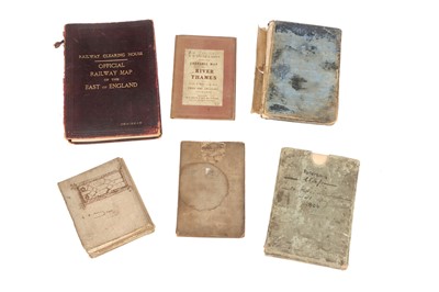


PATERSON'S TWENTY FOUR MILES ROUND LONDON, WITH REFERENCE TO SEATS OF THE NOBILITY AND GENTRY
published 1806, PRINTED for the PROPRIETORS, BOWLES and CARVER, No.69 St. Paul's Church Yard ... Roads and Distances ... agreeable to those given ... by Daniel Paterson, 69 cm x 68 cm, presented in the original cardboard sleeve; together with Railway Clearing House OFFICIAL RAILWAY MAP of the EAST of ENGLAND, chairman's copy [damage to the cover], maritime 1823 New and Correct Map of London Westminster and Southwark, plus earlier R. Wilkinson map of the same area dated 1787, a Royal Naval Boys Manual of Seamanship and Gunnery, fifth edition, and W.H. Smith map of the Thames (6)
Sold for £200
Result plus buyers premium
published 1806, PRINTED for the PROPRIETORS, BOWLES and CARVER, No.69 St. Paul's Church Yard ... Roads and Distances ... agreeable to those given ... by Daniel Paterson, 69 cm x 68 cm, presented in the original cardboard sleeve; together with Railway Clearing House OFFICIAL RAILWAY MAP of the EAST of ENGLAND, chairman's copy [damage to the cover], maritime 1823 New and Correct Map of London Westminster and Southwark, plus earlier R. Wilkinson map of the same area dated 1787, a Royal Naval Boys Manual of Seamanship and Gunnery, fifth edition, and W.H. Smith map of the Thames (6)
Auction: Fine Antiques and Works of Art including Medical Antiques, 15th Sep, 2022
Fine Antiques and Works of Art including Medical Antiques
Viewing
12th September 2022 10am - 3pm
13th September 2022 10am - 3pm
14th September 2022 10am - 3pm

